
 ,
,
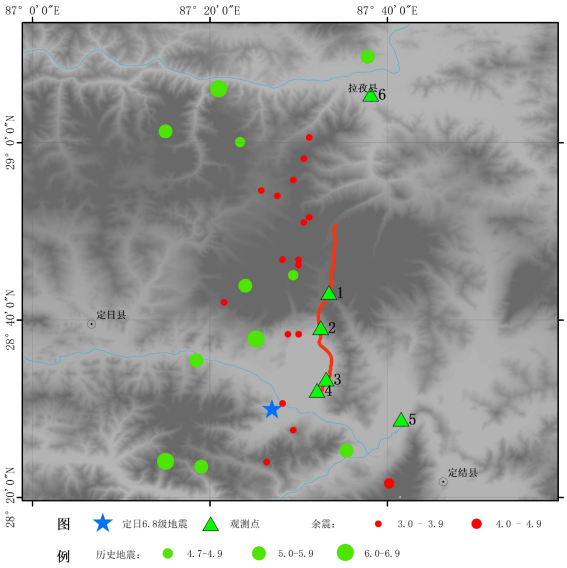
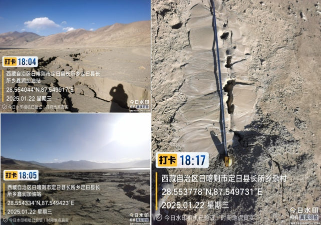
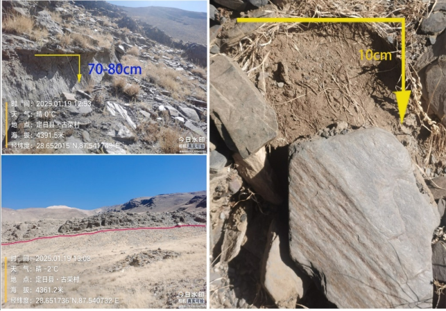
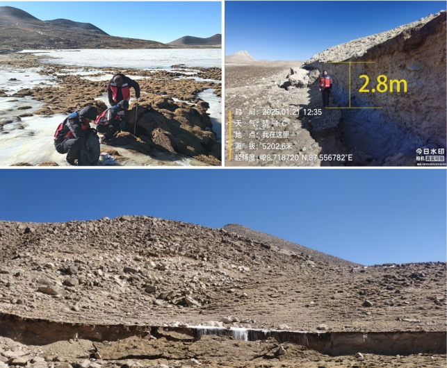
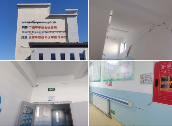
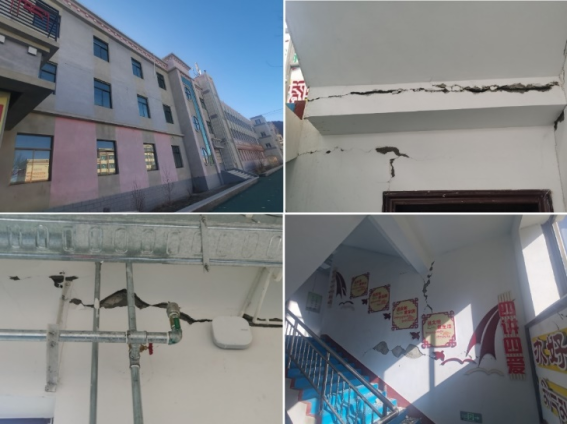
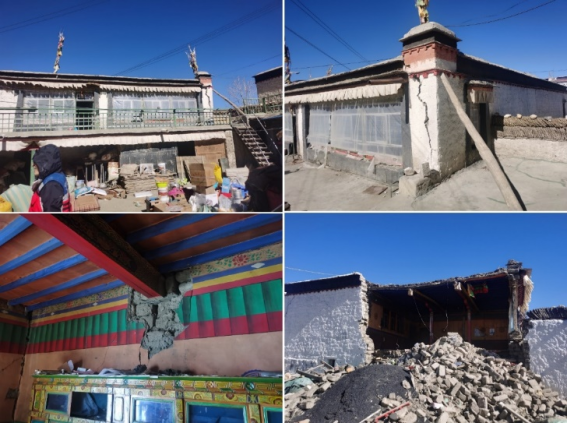
On January 7, 2025, a magnitude 6.8 earthquake occurred in Tingri County, Shigatse City, Tibet Autonomous Region. The Dengmo Cuo fault (one of the north-south rift fault systems on the Qinghai-Tibet Plateau, a main fault in the Shenzha-Dingjie fault zone, with a trace near NS, a westward inclination and a near vertical dip angle) formed a rupture zone with a vertical dislocation with a height of nearly 3m and a cumulative width of about 300m, which caused heavy casualties and property losses to the earthquake area. The observation of Dengmo Cuo fault shows that the fault fault differs greatly in different site conditions, which reflects the influence of site conditions on the fault fault. Houses and buildings in Quxia Town, Lazi County, which is 66km from the epicenter, also suffered serious damage, with the intensity reaching VII degree. This paper investigates the earthquake damage of hospitals, schools and houses in Quxia Town, Lazi County, and mainly analyzes the reasons for the earthquake damage of houses. It is concluded that the main reason is that Lazi County is located in the extension direction of Dengmo Cuo fault. The strong fault misalignment causes the area with earthquake intensity above VII to expand by more than 30% compared with the earthquake of the same magnitude. At the same time, the seismic liquefaction of the superimposed site and the insufficient seismic capacity of houses and buildings have caused the loss of this earthquake disaster to be more serious than that of the earthquake of the same magnitude. Lazi County is located in the northward extension direction of Dengmo Cuo fault, and it is located in the place where the Shenzha-Dingjie fault zone is distributed. It is likely that the dislocation of hidden faults has occurred, but it does not extend to the surface. This study can provide reference for urban planning and seismic fortification near active fault zones in Tibet.
| Published in | Science Research (Volume 14, Issue 4) |
| DOI | 10.11648/j.sr.20261404.21 |
| Page(s) | 218-225 |
| Creative Commons |
This is an Open Access article, distributed under the terms of the Creative Commons Attribution 4.0 International License (http://creativecommons.org/licenses/by/4.0/), which permits unrestricted use, distribution and reproduction in any medium or format, provided the original work is properly cited. |
| Copyright |
Copyright © The Author(s), 2026. Published by Science Publishing Group |
Dingri 6.8 Magnitude Earthquake, Dengmo Cuo Fault, Lazi County, Buildings Damage, Seismic Liquefaction
A | B | C | R0 | σ | 备注 |
|---|---|---|---|---|---|
6.458 | 1.2746 | -4.4709 | 25 | 0.6636 | 青藏区 |
3.3682 | 1.2746 | -3.3119 | 9 | 0.6636 |
烈度 | Ⅸ | Ⅷ | Ⅶ | Ⅵ | ||||
|---|---|---|---|---|---|---|---|---|
长半轴(km) | 短半轴(km) | 长半轴(km) | 短半轴(km) | 长半轴(km) | 短半轴(km) | 长半轴(km) | 短半轴(km) | |
实测值 | 17 | 7 | 25 | 13 | 68 | 31 | 112 | 68 |
Ms6.8 | 5 | 3 | 18 | 10 | 47 | 29 | 96 | 67 |
范围扩大比 | 240% | 133% | 39% | 30% | 45% | 7% | 17% | 1% |
Mw7.0 | 7 | 4 | 24 | 13 | 58 | 36 | 113 | 82 |
范围扩大比 | 143% | 75% | 4% | 0% | 17% | -14% | -1% | -17% |
王继(1972-),男,高级工程师,主要从事地震活动性和危险性研究。 |
| [1] | 刘志成, 高战武, 徐伟. 西藏定日6.8级地震发生的地质构造背景[J]. 防灾博览, 2025, (01): 36-39. |
| [2] |
USGS. M7.1-2025 Southern tibetan plateau earthquake [EB/OL]. [2025-01-07].
https://earthquake.usgs.gov/earthquakes/eventpage/us6000pi9w/finite-fault |
| [3] | 中国地震局地球物理研究所. 2025年1月7日西藏日喀则市定日县 6.8 级地震科技支撑简报[EB/OL]. [2025-01-07]. |
| [4] | 卢寿德. GB17741-2005《工程场地地震安全性评价》宣贯教材 [J]. 北京: 中国标准出版社. 2006. |
| [5] | 王东明. 西藏定日6.8级地震灾害现场调查与分析 [J]. 防灾博览, 2025, (01): 12-21. |
| [6] | 邢珂, 黎昊, 张乐乐, 等. 2025年西藏定日MS6.8地震地表破裂与震害特征分析 [J]. 安全与环境工程, 2025, 32(02): 20-30. |
| [7] | 石峰, 梁明剑, 罗全星, 等. 2025年1月7日西藏定日6.8级地震发震构造与同震地表破裂特征 [J]. 地震地质, 2025, 47(01): 1-15. |
| [8] | 邵延秀, 王爱生, 刘静, 等. 2025年1月7日西藏定日地震地表破裂特征和野外同震位移测量初步结果[J]. 地球科学, 2025, 50(05): 1677-1695. |
| [9] | 国家地震局. 鄂尔多斯周缘活动断裂系 [M]. 北京: 地震出版社, 1988. |
| [10] | 李小军, 孙晓燕, 荣棉水.等, 云南漾濞6.4级地震房屋震害特征受地震动方向性和场地条件的影响 [J]. 应用基础与工程科学学报, 2023, 31(3): 650-662. |
| [11] | 王龙, 李小军, 杨理臣, 等, 青海玛多7.4级地震发震断裂特性及工程震害成因分析研究 [J]. 应用基础与工程科学学报, 2023, 31(5): 1219-1228. |
| [12] | 徐伟, 刘志成, 蔡晓光, 等. 西藏定日6.8级地震同震地表破裂与湖岸地表变形特征及成因讨论 [J]. 震灾防御技术, 2025, 20(02): 221-232. |
| [13] | 安晓文, 李丹. 鲁甸6.5级地震建筑典型震害现象分析 [J], 建筑结构, 2020, 50(7): 28-36. |
| [14] | 邱斌, 赵宝生, 刘有军, 等. 云南“10.07景谷地震”建筑结构震害分析 [J]. 建筑结构, 2017. 47(1): 50-54. |
| [15] | 洪海春, 尤捷, 陶小三, 等, 2014年云南鲁甸地震和景谷地震的震害对比研究 [J]. 地震工程学报,2015, 37(4): 1013-1022. |
APA Style
Ji, W., Xueping, S., Peixuan, L., Zhanwu, G., Zhicheng, L., et al. (2026). Rupture Characteristics and Lhatse County Building Damage Features of the Dingri 6.8 Magnitude Earthquake. Science Research, 14(4), 218-225. https://doi.org/10.11648/j.sr.20261404.21
ACS Style
Ji, W.; Xueping, S.; Peixuan, L.; Zhanwu, G.; Zhicheng, L., et al. Rupture Characteristics and Lhatse County Building Damage Features of the Dingri 6.8 Magnitude Earthquake. Sci. Res. 2026, 14(4), 218-225. doi: 10.11648/j.sr.20261404.21
@article{10.11648/j.sr.20261404.21,
  author = {Wang Ji and Song Xueping and Liu Peixuan and Gao Zhanwu and Liu Zhicheng and Xu Wei and Cai Xiaoguang},
  title = {Rupture Characteristics and Lhatse County Building Damage Features of the Dingri 6.8 Magnitude Earthquake},
  journal = {Science Research},
  volume = {14},
  number = {4},
  pages = {218-225},
  doi = {10.11648/j.sr.20261404.21},
  url = {https://doi.org/10.11648/j.sr.20261404.21},
  eprint = {https://article.sciencepublishinggroup.com/pdf/10.11648.j.sr.20261404.21},
  abstract = {On January 7, 2025, a magnitude 6.8 earthquake occurred in Tingri County, Shigatse City, Tibet Autonomous Region. The Dengmo Cuo fault (one of the north-south rift fault systems on the Qinghai-Tibet Plateau, a main fault in the Shenzha-Dingjie fault zone, with a trace near NS, a westward inclination and a near vertical dip angle) formed a rupture zone with a vertical dislocation with a height of nearly 3m and a cumulative width of about 300m, which caused heavy casualties and property losses to the earthquake area. The observation of Dengmo Cuo fault shows that the fault fault differs greatly in different site conditions, which reflects the influence of site conditions on the fault fault. Houses and buildings in Quxia Town, Lazi County, which is 66km from the epicenter, also suffered serious damage, with the intensity reaching VII degree. This paper investigates the earthquake damage of hospitals, schools and houses in Quxia Town, Lazi County, and mainly analyzes the reasons for the earthquake damage of houses. It is concluded that the main reason is that Lazi County is located in the extension direction of Dengmo Cuo fault. The strong fault misalignment causes the area with earthquake intensity above VII to expand by more than 30% compared with the earthquake of the same magnitude. At the same time, the seismic liquefaction of the superimposed site and the insufficient seismic capacity of houses and buildings have caused the loss of this earthquake disaster to be more serious than that of the earthquake of the same magnitude. Lazi County is located in the northward extension direction of Dengmo Cuo fault, and it is located in the place where the Shenzha-Dingjie fault zone is distributed. It is likely that the dislocation of hidden faults has occurred, but it does not extend to the surface. This study can provide reference for urban planning and seismic fortification near active fault zones in Tibet.},
 year = {2026}
}
TY  - JOUR
T1  - Rupture Characteristics and Lhatse County Building Damage Features of the Dingri 6.8 Magnitude Earthquake
AU  - Wang Ji
AU  - Song Xueping
AU  - Liu Peixuan
AU  - Gao Zhanwu
AU  - Liu Zhicheng
AU  - Xu Wei
AU  - Cai Xiaoguang
Y1  - 2026/08/13
PY  - 2026
N1  - https://doi.org/10.11648/j.sr.20261404.21
DO  - 10.11648/j.sr.20261404.21
T2  - Science Research
JF  - Science Research
JO  - Science Research
SP  - 218
EP  - 225
PB  - Science Publishing Group
SN  - 2329-0927
UR  - https://doi.org/10.11648/j.sr.20261404.21
AB  - On January 7, 2025, a magnitude 6.8 earthquake occurred in Tingri County, Shigatse City, Tibet Autonomous Region. The Dengmo Cuo fault (one of the north-south rift fault systems on the Qinghai-Tibet Plateau, a main fault in the Shenzha-Dingjie fault zone, with a trace near NS, a westward inclination and a near vertical dip angle) formed a rupture zone with a vertical dislocation with a height of nearly 3m and a cumulative width of about 300m, which caused heavy casualties and property losses to the earthquake area. The observation of Dengmo Cuo fault shows that the fault fault differs greatly in different site conditions, which reflects the influence of site conditions on the fault fault. Houses and buildings in Quxia Town, Lazi County, which is 66km from the epicenter, also suffered serious damage, with the intensity reaching VII degree. This paper investigates the earthquake damage of hospitals, schools and houses in Quxia Town, Lazi County, and mainly analyzes the reasons for the earthquake damage of houses. It is concluded that the main reason is that Lazi County is located in the extension direction of Dengmo Cuo fault. The strong fault misalignment causes the area with earthquake intensity above VII to expand by more than 30% compared with the earthquake of the same magnitude. At the same time, the seismic liquefaction of the superimposed site and the insufficient seismic capacity of houses and buildings have caused the loss of this earthquake disaster to be more serious than that of the earthquake of the same magnitude. Lazi County is located in the northward extension direction of Dengmo Cuo fault, and it is located in the place where the Shenzha-Dingjie fault zone is distributed. It is likely that the dislocation of hidden faults has occurred, but it does not extend to the surface. This study can provide reference for urban planning and seismic fortification near active fault zones in Tibet.
VL  - 14
IS  - 4
ER  -
Department of Seismic Zoning and Earthquake Resistance Precaution, China Earthquake Disaster Prevention Center, Beijing, China

Information


 Share This Article
 Twitter
 Linked In
 Facebook
 Copy
Copy Download